
County Mayo has ten recorded Ogham stones, making it one of the less obvious but genuinely rewarding destinations for anyone interested in ancient Irish heritage. Kerry gets most of the attention, and the concentration of inscriptions there is hard to match anywhere. But Mayo’s stones sit in some remarkable settings — coastal sand dunes, a hillside beside a holy well, a leaning pillar in low-lying pasture beside a stream — and visiting them gives you a side of the west of Ireland that most tourists never see.
This guide covers all nine stones you can actually visit in the county (one is now in the National Museum of Ireland in Dublin), groups them into a logical three-day route, and includes things worth seeing nearby at each stop.
The Mayo Ogham Stones at a Glance
| Stone | Location | Inscription | In situ? |
|---|---|---|---|
| Ballybeg | Near Ballyhaunis | C[A]SEGNI MAQI | Yes |
| Island | Near Knock | CUNALEGI AV[I] CUNACANOS | Yes (fallen) |
| Rusheens West | Kilmovee | ALATTOS MAQI BR[---] | Yes |
| Kilgarvan | Near Foxford | DOTAGNI | Yes (lying flat) |
| Corrower | Near Attymass | [MA]Q CERAN AVI ADECETAIMIN | Yes |
| Breastagh | Near Killala | LEGG[..]MAQ CORRBRI MAQ AMMLLOG[I]TT | National monument |
| Aghaleague | Near Killala | MAQACTO MAQ GAR[---] | Yes (leaning) |
| Cross Abbey | Belmullet peninsula | Fragmentary | Built into wall |
| Dooghmakeon | Near Louisburgh | [---]OVI MAQI | Yes (re-erected) |
You can plot all of these on our Ogham stones map before you travel.
Planning the Route
The stones fall into three geographic clusters. The southeast group sits around Ballyhaunis and Knock, the central group is near Foxford and Attymass, and the northern and western arc runs from Killala Bay out to the Erris peninsula and down the coast to Louisburgh.
Flying into Knock Airport or driving from Galway, the southeast cluster is the natural starting point. Ballina is the best overnight base for the central and northern stones. Westport works well for the final day along the west coast.
Open the full route in Google Maps — all 9 stones in order, ready to navigate.
Day 1: The Southeast Mayo Ogham Stones
Ballybeg Ogham Stone (I-MAY-004)
The Ballybeg stone stands on a broad ridge near the Mayo-Roscommon border with long views across the valley to the south. At 2.2 metres tall it makes a confident impression in the landscape. The inscription reads C[A]SEGNI MAQI, meaning “of Caissíne, son of…” — the father’s name has been lost to weathering. The name Caissíne translates roughly as “little curly-haired one” from the Old Irish cas (curly) and a diminutive suffix.
It’s a straightforward find on farmland and gives you an immediate feel for how these stones were sited: on elevated ground, visible from some distance, commanding their surroundings.
Worth seeing nearby: Ballyhaunis has a well-preserved Augustinian friary from 1430, one of the better surviving examples in Connacht. Knock Shrine is less than twenty minutes away and the basilica complex is architecturally interesting whatever your own beliefs.
Island Ogham Stone (I-MAY-001)
A couple of kilometres from Ballybeg, the Island stone occupies an unusual position at the top of a barrow on a steep ridge. It was originally upright but a century of slow tilting has left it almost horizontal. The inscription CUNALEGI AV[I] CUNACANOS (of Conlang, grandson of Conchaín) now runs along what is effectively the uppermost surface.
It’s a slightly melancholy sight — a monument that stood for over a thousand years and has been losing its fight with gravity since at least the 1890s when it was first recorded. But the barrow setting still has presence, and the long views from the ridge are genuinely good.
Worth seeing nearby: Ballintubber Abbey, founded in 1216 and one of the only abbeys in Ireland in continuous use since its foundation, is about twenty minutes north. It’s one of the quieter great monuments in the west.
Rusheens West Ogham Stone, Kilmovee (I-MAY-003)
The Rusheens West stone stands on a low circular platform beside a holy well dedicated to St Mobhí. The inscription ALATTOS MAQI BR[---] (of Allaid, son of Br…) is linguistically among the earliest in Mayo, probably pre-sixth century. The name Alattos means “the wild one” in Old Irish and is attested on several Kerry stones too, but the Rusheens example is thought to be the oldest.
At some point before its current position, the stone served as a kneeling stone around the well. The setting — well, platform, rush-grown field, church and graveyard two hundred and fifty metres to the southeast — is one of the more atmospheric on the whole trip.
Worth seeing nearby: The Kilmovee Heritage Trail connects several monuments in the area. Knock is about twenty minutes south.
Day 2: Central Mayo and the Killala Bay Ogham Stones
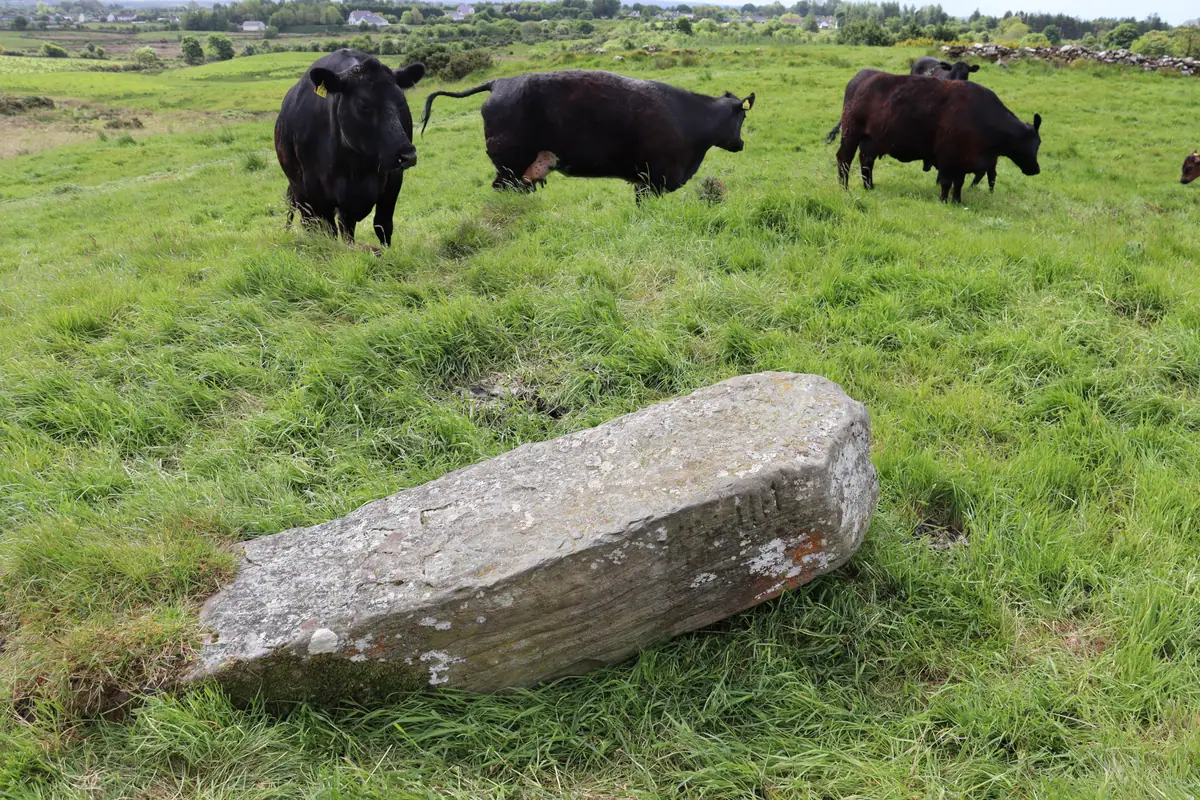
Kilgarvan Ogham Stone (I-MAY-010)
The Kilgarvan stone was discovered on Good Friday 2000 by Noel O’Neill, Gerry Bracken and others on a day’s fieldwork — a reminder that the tally of known Irish Ogham stones isn’t closed. It’s a wedge-shaped granite pillar, 1.4 metres long, lying flat in the northeast corner of Kilgarvan graveyard. The site itself is old: the church here is thought to have been founded by St Féichéine in the seventh century, and the placename Cill na nGarbhán preserves the name of the local patron saint Garvan.
The inscription reads DOTAGNI, a single personal name dated by archaeologist Mícheál Moore to approximately 400–599 AD. It most likely marks the grave of a local chieftain or person of standing in the early Christian community at this site.
Worth seeing nearby: Foxford is a few kilometres south. The Foxford Woollen Mills has a decent visitor experience and the town sits on the River Moy, one of the finest salmon rivers in Ireland.
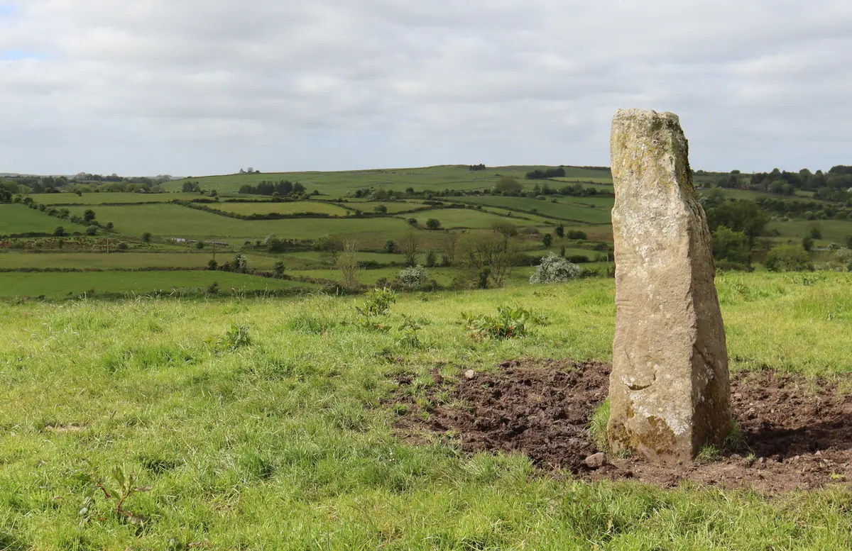
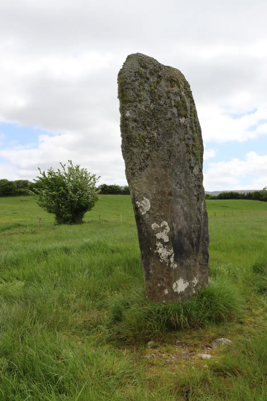
Corrower Ogham Stone (I-MAY-005)
The Corrower stone is the physical standout of the entire circuit. At three metres tall it’s among the largest Ogham stones in Ireland, and the current thinking is that it started life as a prehistoric standing stone and was only later adapted by an Ogham carver — which would make it doubly ancient. The inscription reads [MA]Q CERAN AVI ADECETAIMIN (son of Cíarán, grandson of A?).
It stands in a pasture field next to a farmyard, a cairn-topped hill to the south and a rath on a ridge to the north. Everything in the landscape relates to something else. It’s a good stone for understanding how this whole tradition worked, not isolated monuments but markers in a living, layered territory.
Worth seeing nearby: Pontoon, where Lough Conn meets Lough Cullin, is one of the more quietly beautiful spots in Mayo. The drive north toward Ballina along the lough shores is easy and scenic.
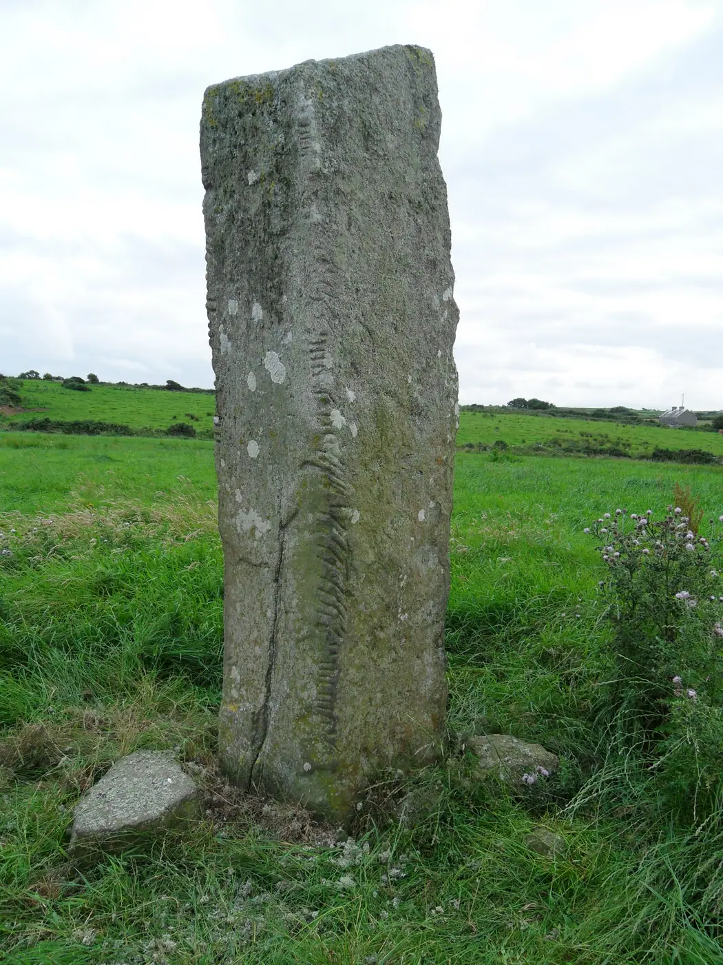
Breastagh Ogham Stone (I-MAY-008) — National Monument
The Breastagh stone is the most important on the circuit and the easiest to access, as it’s a national monument in state guardianship. It was found lying in a field in 1874 by an English tourist, re-erected at its current location, and has been protected ever since. At 2.75 metres tall, it’s a substantial monument.
The inscription is long and complex: [LEGG..]SDULEGESCAD MAQ CORRBRI MAQ AMMLLOG[I]TT. The genealogical sequence has attracted significant scholarly attention — some have connected the father’s name with a king of Connacht who died around 440 to 450 AD, though the linguistic evidence points more to a late sixth or early seventh century date. Either way, this stone appears to record a lineage reaching into the royal families of early medieval Ireland.
Worth seeing nearby: Killala is one of the most historically layered small towns in the west. The round tower is early medieval and one of the best preserved in Connacht. The town overlooks Killala Bay, where French forces landed in 1798 in support of the United Irishmen rebellion — that whole northwest Mayo landscape carries the memory of it. Moyne Abbey and Rosserk Abbey are both within easy reach, two of the finest late medieval friaries in Ireland.
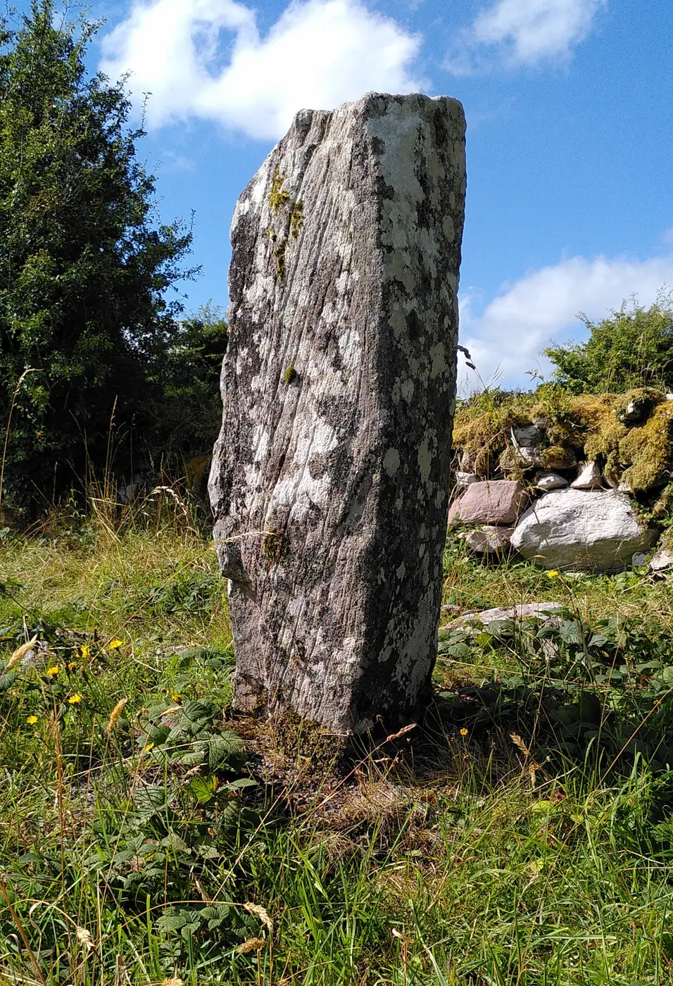
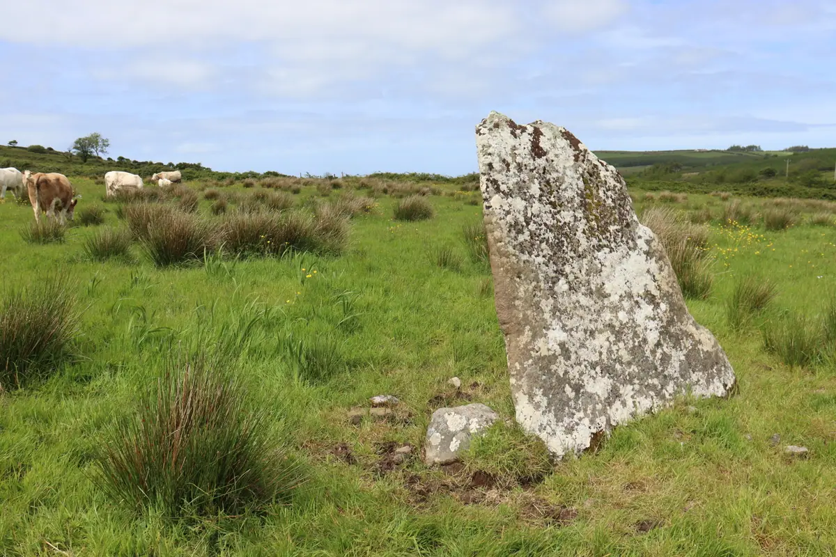
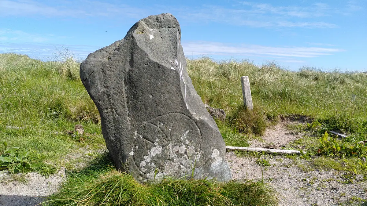
Aghaleague Ogham Stone (I-MAY-007)
A few kilometres from Breastagh, the Aghaleague stone leans noticeably to the northwest in a low-lying, damp pasture field beside a stream. Farm stock have used the southwest face as a scratching post and may have erased part of the inscription over the centuries. What survives reads MAQACTO MAQ GAR[---].
The townland name, Achadh Liag, means “field of the pillar stone” in Irish, evidence that the stone was already old and established enough to define the local landscape long before anyone thought to record it academically.
Worth seeing nearby: The Céide Fields are about twenty kilometres west along the north coast road, a Neolithic farming landscape preserved under blanket bog that is one of the most extensive Stone Age sites in the world. The visitor centre sits on a dramatic clifftop above the Atlantic and is worth the detour.
Day 3: The West Mayo Ogham Stones
Cross Abbey Ogham Stone (I-MAY-009)
The drive out to Cross Abbey on the Belmullet peninsula is one of the better parts of this trip in its own right. The landscape empties steadily as you push west through Erris, and the abbey when you reach it is a 10th-century ruin sitting close to Broadhaven Bay. The Atlantic has been slowly eating into the abbey grounds over the centuries, but substantial parts of the ruins and burial ground remain.
The Ogham stone — roughly two metres tall — is built into the corner of an old grave structure on the east wall of the church. Its inscription is largely illegible due to centuries of weathering and exposure, and we may never know who it was meant to commemorate. The stone wasn’t included in Macalister’s 1945 Corpus and was only formally recorded more recently. The graveyard also holds the graves of several notable figures from the history of the Mullet Peninsula.
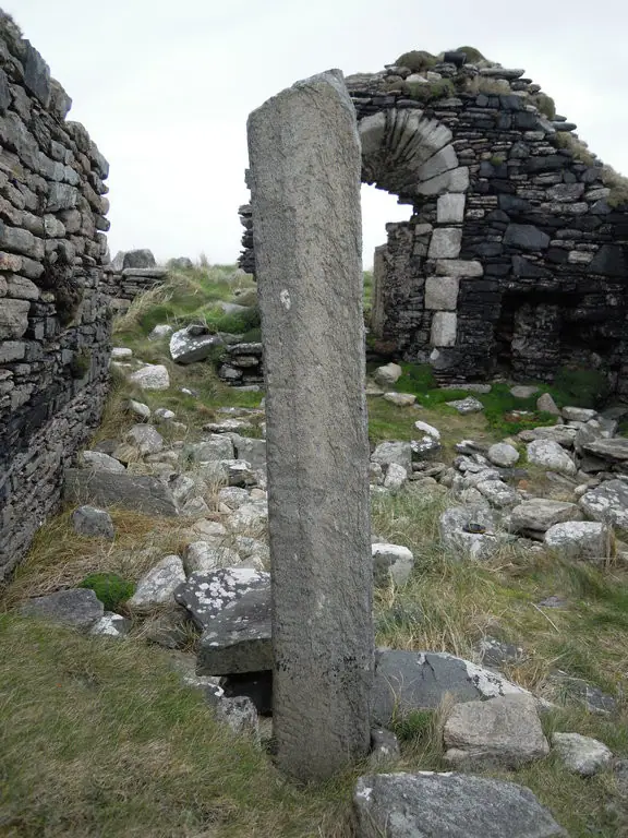
It’s the westernmost Ogham stone in Mayo. Standing here at the edge of the Mullet, the distance from the main Irish Ogham belt in Cork and Kerry feels very real.
Worth seeing nearby: Benwee Head to the north is a spectacular cliff walk on a clear day. The village of Belmullet is a working town on the neck of the peninsula and a good place to stop for food. Broadhaven Bay itself is one of the least-visited stretches of coastline in Ireland.
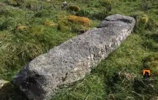
Dooghmakeon Ogham Stone (I-MAY-006)
The Dooghmakeon stone is the strangest in the county for setting. It stands in marram grass on sand dunes 120 metres from the beach at Sruhir Strand, near Louisburgh. It’s a limestone cross-slab with an inscribed cross on the south face and a heavily weathered Ogham inscription on the edge that reads [---]OVI MAQI.
When it was first noticed in 1897 the stone was already lying flat on the dunes. A local priest re-erected it, possibly upside down. The combination of early Christian iconography, Ogham script, and Atlantic dune setting is unlike anything else on the Irish Ogham circuit.
Worth seeing nearby: Croagh Patrick is a short drive north. Even without walking the mountain the views from the road at Murrisk across Clew Bay justify the stop. Westport is twenty minutes further on, consistently one of the best towns in the west for food and an evening. The Delphi Valley between Louisburgh and Leenane makes for a beautiful drive south at the end of the trip.
Where to Stay in Mayo
Ballina is the most convenient base for the central and northern stones. Westport suits the final day. Castlebar works if you prefer to be centrally located throughout.
Practical Tips for Visiting Mayo Ogham Stones
Most of the in-situ stones are on private farmland or in graveyards accessible from public roads. The Breastagh stone is a national monument in state guardianship and the most straightforward to access. For farmland stones, a detailed OS map and a willingness to knock on a door and ask usually works well in rural Mayo. The stones are recorded monuments and landowners are generally aware of them.
Mayo County Council and the Heritage Council funded a 3D recording project for these stones in 2022, so photogrammetric models exist for most of them if you want to examine the inscriptions in detail before you visit.
The full records for all Mayo Ogham stones, including inscriptions, coordinates, and photographs, are in our Ogham stone database.
Frequently Asked Questions
How many Ogham stones are in County Mayo?
Ten Ogham stones have been recorded in County Mayo. Nine are located within the county itself. The tenth, the Kilmannin stone (I-MAY-002), was removed from its original site and is now in the National Museum of Ireland in Dublin.
Where is the most accessible Ogham stone in Mayo?
The Breastagh stone near Killala (I-MAY-008) is a national monument in state guardianship and the easiest to visit. It stands in the open and there is no access restriction.
How long does it take to visit all the Mayo Ogham stones?
Three days is comfortable. The stones fall into three geographic clusters, and each cluster is manageable as a day trip with time to take in the surrounding area.
Can you visit Ogham stones in Mayo year round?
Yes. Most are in the open air on farmland or in graveyards and have no seasonal restrictions. Winter visits can be atmospheric, though the roads in Erris and north Mayo can be quiet and you should check conditions before driving out to the western stones.
What is the oldest Ogham stone in Mayo?
The Rusheens West stone (I-MAY-003) near Kilmovee is linguistically one of the earliest, probably pre-sixth century. The name it records, ALATTOS, preserves a pre-apocope ending that suggests it predates most of the other Mayo inscriptions.